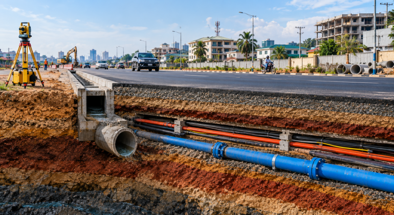

Imagine excavating a road to install a drainage system, only to strike an unrecorded water pipe or live electrical cable. Subsurface utility damages disrupt construction timelines, threaten workers, and trigger massive financial losses. Before any excavation begins, knowing what lies beneath the ground is a mandatory phase of modern project planning. While international agencies like the FHWA highlight these risks globally, contractors locally must comply with the infrastructure frameworks provided by the Federal Ministry of Works to prevent costly project delays and structural damage. FMW
What is Subsurface Utility Mapping (SUM)?
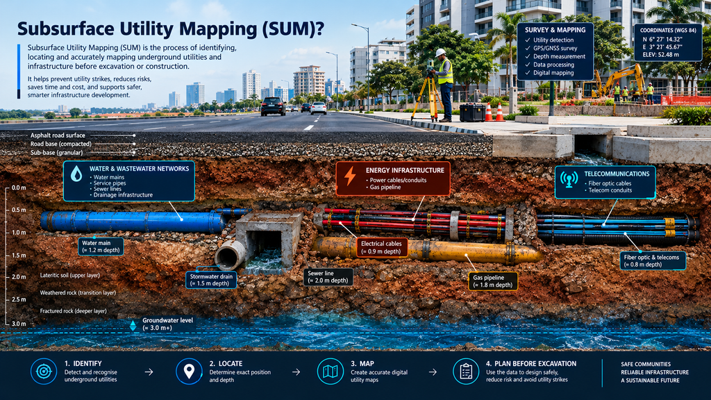
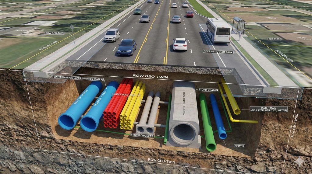
Subsurface utility mapping (SUM) is the technical process of identifying, locating, and mapping underground utility infrastructure within a specific project zone. This survey creates a precise digital or physical map of the hidden subterranean network before any excavation kicks off. Depending on your construction site, this essential survey locates critical buried assets such as:
- Water & Wastewater Networks: Municipal water supply mains, drainage channels, and sewer lines.
- Energy Infrastructure: High-voltage electricity cables and gas pipelines.
- Telecom Links: Fiber-optic networks, internet wires, and telephone cables.
The primary goal of utility mapping is to give engineering teams accurate data before starting any excavation, drilling, or infrastructure upgrades. ASCE
Why Does Utility Mapping Matter in Urban Areas?
Why does utility mapping matter in dense urban centers? Rapidly expanding cities like Lagos and Ibadan feature packed underground networks where power lines, fiber cables, and water mains compete for limited subterranean space. Without accurate mapping, routine road excavations quickly trigger service blackouts, expensive project redesigns, and structural damage. Implementing subsurface utility engineering early allows developers and contractors to detect potential conflicts before breaking ground. In these high-risk zones, utilizing state geospatial platforms like OyoGISS ensures better coordination, protects vital public utilities, and prevents catastrophic budget overruns.
How Are Underground Utilities Detected?
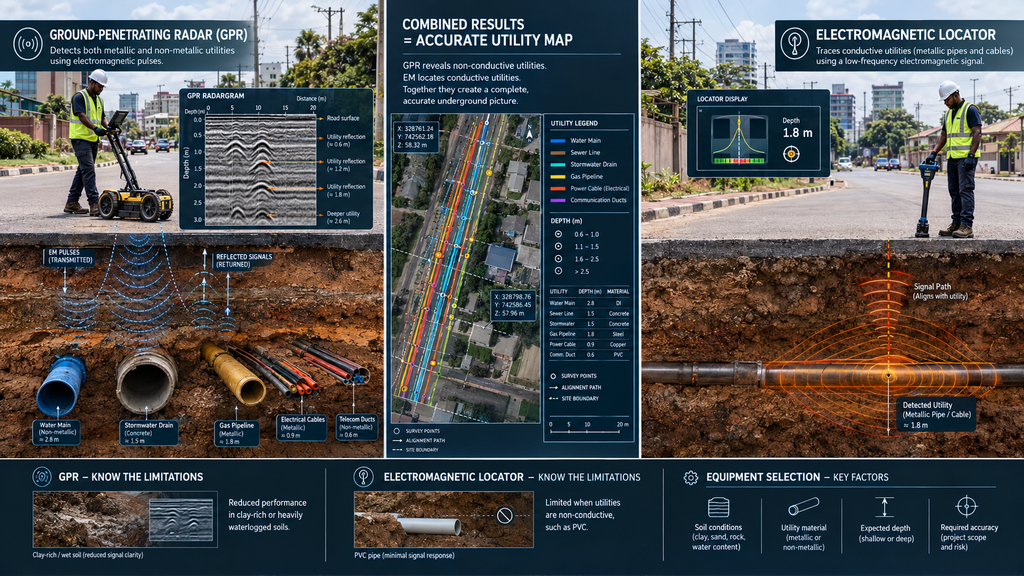
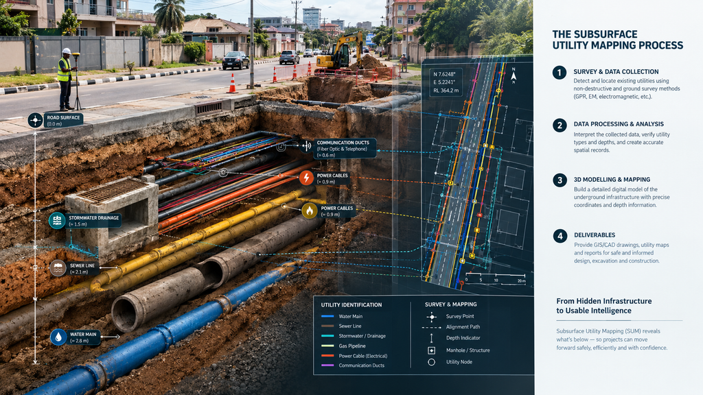
Modern subsurface utility mapping combines legacy utility records, onsite reconnaissance, and advanced geophysical scanning. Technicians use Ground-Penetrating Radar (GPR) to emit electromagnetic pulses that reflect off buried metallic and non metallic hazards. Concurrently, digital underground utility locator equipment traces conductive pipes and live electrical lines. Merging these technologies creates a comprehensive overview of subterranean space.
However, geophysics has environmental limitations. Clay-rich or heavily waterlogged soils damp GPR waves, while electromagnetic systems fail against non-conductive materials like modern PVC pipes. Surveying teams must select specific equipment arrays based on soil conditions, pipe materials, and the project’s exact depth and accuracy requirements.
From Detection to a Useful Utility Map
Locating a buried service is only the first step. For data to be useful, it must be interpreted, surveyed, and converted into precise as-built drawings that civil engineering teams can safely follow. Professional mapping frameworks categorize these findings into distinct quality levels to communicate data confidence. While international standards like ASCE 38-22 provide a framework for these quality tiers, local compliance with the Council for the Regulation of Engineering in Nigeria (COREN) ensures that these underground records are legally validated by registered engineers before site mobilization.
Where the risk of an utility strike is severe, physical verification through nondestructive vacuum excavation is highly recommended. Ultimately, an effective utility map must transparently convey both its technical findings and physical limitations, rather than treating every radar signal as a guaranteed asset location.
How Does Utility Mapping Support Sustainability?
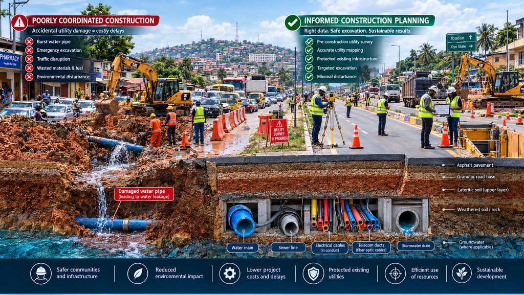

Accurate underground mapping is a core pillar of sustainable infrastructure development. Striking buried water lines or electricity conduits does more than drain project budgets; it forces emergency street repairs that trigger massive traffic congestion and spike vehicle emissions. Research confirms that uncoordinated excavation prolongs municipal street works, worsening urban energy waste and environmental degradation.
However, utility mapping is not a standalone solution. Its true value lies in giving urban planners and asset managers the precise data needed to execute green construction practices. When integrated with the environmental and professional frameworks advocated by the Nigerian Society of Engineers, subsurface mapping optimizes resource use, minimizes ground disturbance, and fosters resilient, eco-friendly city growth.
When Should Subsurface Utility Mapping Be Carried Out?
Subsurface mapping is most effective when integrated into the earliest stages of pre-construction planning to actively shape civil engineering design decisions. Executing these detailed surveys must be prioritized well before road excavations, drainage installations, or pipeline upgrades begin. Introducing utility engineering early gives project teams the essential runway to pinpoint underground bottlenecks, re-evaluate routing options, and adjust structural layouts before heavy machinery mobilizes.
Waiting until excavation begins guarantees delays. By embedding sub-surface investigations directly into the initial project scoping phase as championed by the accountability frameworks of the Bureau of Public Procurement contractors can eliminate preventable utility strikes, secure accurate cost estimations, and streamline the entire infrastructure delivery timeline.
Partner with the Experts
When it comes to safeguarding your project timeline and budget, guesswork is your greatest liability. As a premier Nigerian indigenous engineering firm, Solo-May Geoservices delivers world-class geophysical surveying and advanced subsurface utility investigations. Our tailored scanning methods help project teams accurately visualize hidden underground conditions, mapping out potential utility conflicts before heavy machinery ever sets foot on your site.
Before you excavate, remember, understanding what lies beneath the surface is the absolute foundation of safer workflows, smarter structural planning, and responsible urban infrastructure development. Don’t leave your site safety to chance or outdated registries.
Ready to eliminate excavation blind spots on your next project?
Contact Solo-May Geoservices Today to consult with our expert surveying team, secure your site, and ensure your development is built on precision data.